Topographic Survey

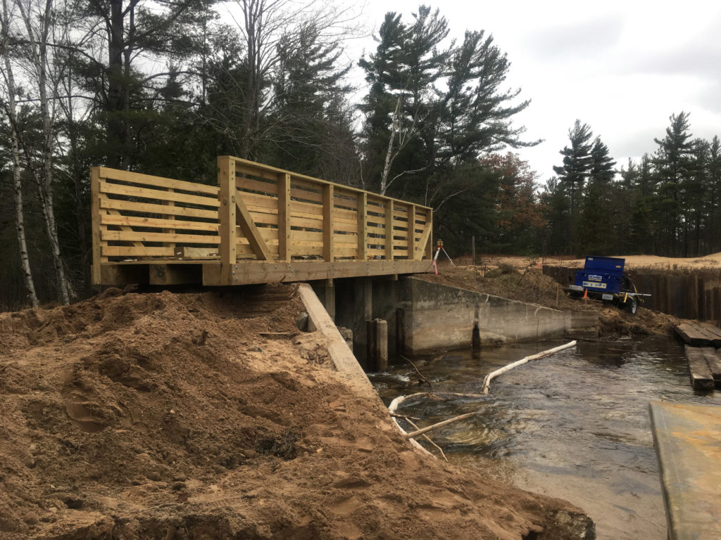
O’Neal Lake Dam Restoration

O’Neal Lake Dam failed in September of 2014 due to heavy rains. In November of that same year, NFE was retained by the Department of Technology Management and Budget (DTMB) and the Department of Natural Resources (DNR) to investigate the failure of the dam and come up with options to repair it.

The dam was installed in 1952 by the DNR to aid in both water control and to develop a habitat for wildlife. O’Neal Lake is approximately 150 acres in size, and surrounded by Wilderness State Park and privately-owned land. Once the dam failed the lake dried up.

After careful study and evaluation of the dam, NFE proposed five options for repairing the control structure. The Cut-Off Wall/Control Structure Installation option was chosen by DTMB/DNR because it was creating basically a new dam with a 50-year-life expectancy and with minimal maintenance. This option entails placing steel pilings to form a wall in front of the existing dam and filling in between, along with repairing the pedestrian and snowmobile wood crossing. The old dam was retrofitted with a new deck and railings to accommodate an important pedestrian crossing within Wilderness State Park.

NFE prepared engineering plans for demolition, structure improvement, area earthwork, boat launch improvements and construction documents. After DTMB/DNR secure funding for the project, construction started in October 2017, and is expected to be completed spring 2018. NFE also provided both office and site construction administrative services. NFE is proud to be involved with this project that will bring the lake back to the area and its residents, while restoring boating, fishing and a haven for wildlife.

Related Projects

Beltline Greenway Phase I and II Surveying Services

The City of Detroit Economic Growth Corporation (DEGC) contracted with NFE to prepare surveying documents to facilitate the purchase and design of properties associated with the Beltline Greenway project in the City of Detroit. Beltline Greenway when completed will be a 1.5-mile trail, for walking and biking, to connect the neighborhood to the Detroit River.

NFE prepared ALTA/NSPS Land Title Survey and topographic survey for the area between the streets of Belleview and Beaufait from Kercheval Avenue to Jefferson Avenue for the Phase I of this project. Phase II involved the preparation of ALTA/NSPS Land Title Survey, topographic survey and tree survey in the same area as Phase I but from Jefferson Avenue to the Detroit River.

The work included coordination with the City of Detroit DPS to clean all sewers within the project limits to assure existing infrastructure would support the proposed improvements.

The trail when completed will follow a former railroad called the Beltline that connected the Uniroyal site on the Riverwalk and headed North to the Gleaner’s Community Food Bank on Beaufait Street just north of Kercheval Avenue. In anticipation for this project, the City of Detroit rebuilt the East Jefferson Avenue bridge.

Related Projects

Scroll to Top